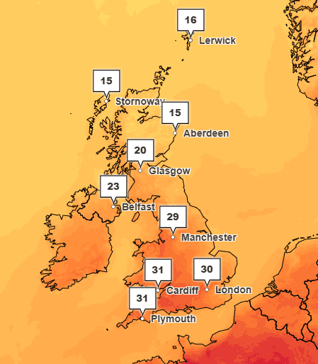
Forecast of next 30 days, UKHSA
Forecast of next 30 days issued by the Met Office on behalf of UKHSA
View current Weather-Health Alerting situation
Overview of hot weather over the next 5 days
Clear skies to start but becoming increasingly cloudy from Monday, especially across the north and west, with spells of light rain possible here. Drier and brighter conditions generally expected in the south with light winds, becoming breezy especially along the coasts. low loud and fog is common along the coast and will spread inland overnight. Potentially thundery showers possible in south and southwest overnight Monday. Medium level threshold temperatures likely to be maintained before cooling in the north and some eastern parts from Monday onwards.
Overview of hot weather over the next 6 to 15 days
High pressure will slowly break down and looses its influence during the week, with a shift to Low pressure possible across the UK during the weekend. There remains some uncertainty but temperatures will gradually cool and could drop below the Low impact temperatures by the end of the week in the north and spread southwads over the weekend. Becoming cloudier with a chance of Thunderstorms in the northwest initially, then spreading across central and southern parts during Saturday and Sunday.
Overview of hot weather over the next 16 to 30 days
This period may start unsettled with sunshine and showers, before a possible return to warm and dry conditions from Wednesday onwards as High pressure builds from the west. Low impact temperature thresholds may be reached across all parts through this period, with the greatest risk in the south.
| Region | Probability of reaching low impact threshold in the next 5 days (%) | Probability of reaching low impact threshold in the next 6–15 days (%) | Probability of reaching low impact threshold in the next 16–30 days (%) | General comments on weather |
|---|---|---|---|---|
| NE | 90 | 30 | 20 | Bright and warm during the day with some thin high cloud. Low cloud and fog overnight along the coast and pushing inland in a developing northeasterly breeze, with the chance of some patchy rain/drizzle over high ground. |
| NW | 95 | 30 | 20 | Bright and warm during the day with some thin high cloud. Low cloud and fog overnight along the coast and pushing inland in a developing northeasterly breeze, with the chance of some patchy rain/drizzle over high ground. |
| YH | 95 | 30 | 30 | Bright and warm during the day with some thin high cloud. Low cloud and fog overnight along the coast and pushing inland in a developing northeasterly breeze, with the chance of some patchy rain/drizzle over high ground. |
| EM | 95 | 50 | 40 | Mostly dry and sunny but often cloudy overnight. Turning more cloudy by Monday with low cloud from the northeast moving southwest overnight. |
| WM | 95 | 50 | 40 | Mostly dry and sunny but often cloudy overnight. Turning more cloudy by Monday with low cloud from the northeast moving southwest overnight. |
| EoE | 95 | 40 | 40 | Fine and settled weather to start with some morning coastal mist and fog patches. Becoming cloudier from Monday with the chance of some thundery showers overnight. |
| Lon | 95 | 50 | 40 | Fine and settled weather to start with some morning coastal mist and fog patches. Becoming cloudier from Monday with the chance of some thundery showers overnight. |
| SE | 95 | 40 | 40 | Fine and settled weather to start with some morning coastal mist and fog patches. Becoming cloudier from Monday with the chance of some thundery showers overnight. |
| SW | 95 | 60 | 40 | Fine and settled weather to start with some morning coastal mist and fog patches. Becoming cloudier from Monday with the chance of some thundery showers overnight. |
For further information, please refer to the UKHSA Adverse Weather and Health Plan
All other enquiries can be directed to enquiries@ukhsa.gov.uk